 Ever tried. Ever failed. No matter. Try again. Fail again. Fail better.
From GPT-6 to 3D modeling using Blender in demonstrations, to AI shorts taking up more and more screen time, to robots entering real-world scenarios that seem to have different applications, there is a need for a common set of capabilities: understanding where objects are, how they relate to each other, how their state changes over time, and what the consequences of taking action can be.
Faced with these tasks, basic models need to integrate finite, discrete, and changing observations into coherent, up-to-date spatial understanding and reasoning, prediction, and decision-making. This is the core proposition of spatial intelligence and the basis for the ability to connect multi-modal understanding, content generation, and physical interaction.
What kind of data is needed to make models have these capabilities?
As an associate professor in the Department of Computer Science at the City University of Hong Kong, he heads the Data Intelligence Lab, a long-term research project on data mining, data-driven AI and data value.
In his view, the bottleneck of basic modular spatial intelligence lies not only in architecture but also in data: what data is really useful for the task, how to evaluate whether the model understands space, and how the evaluation results should be trained. This is exactly the direction that the mapping world is exploring, from multi-modal space acquisition, spatial structuring, to model space intelligence evaluation and post-training environments.
Around this route, Mapping Technology has completed two rounds of seed funding in succession over the past few months, totaling tens of millions of yuan.
A turkey, and a "count me in".
Recalling the beginnings of his collaboration with the film industry, Mahjong said that he had little hesitation. After a torch, he accepted the invitation of the founder Kim Il-sung.
At the time, mapping technology was only a few months old and focused on the data and training layer of spatial intelligence. The team has previously accumulated experience in spatial perception, dynamic 3D representation and multimodal acquisition, and now wants to extend this capability to dynamic spatial data, model evaluation and training infrastructure.
Why did a professor at a university studying "data intelligence" choose a startup that was just a few months old?
What attracted him was a specific question: what kind of data could be used when the basic model started to enter the real world?Raising the spatial intelligence of models?
It sounds abstract, but it's very specific in the business of mapping. In addition to collecting more data, what companies need to do is determine which data is useful for the model, how to evaluate, evaluate, and how to breastfeed.
The promise was made simply because the two had a relationship earlier than the start-up. In 2021, through a professor who was also from Steve Liu's doorstep, Kim requested that Ma'an learn about neural networks online. Later, he went to McGill University to study with Dr. Mila Pei, a professor from Ma'an's IEEE Fellow, and Professor Steve Liu, a fellow of the Canadian Academy of Engineering.
He was described as "a brilliant student" at the time, but now he is described as a "very comprehensive entrepreneur".
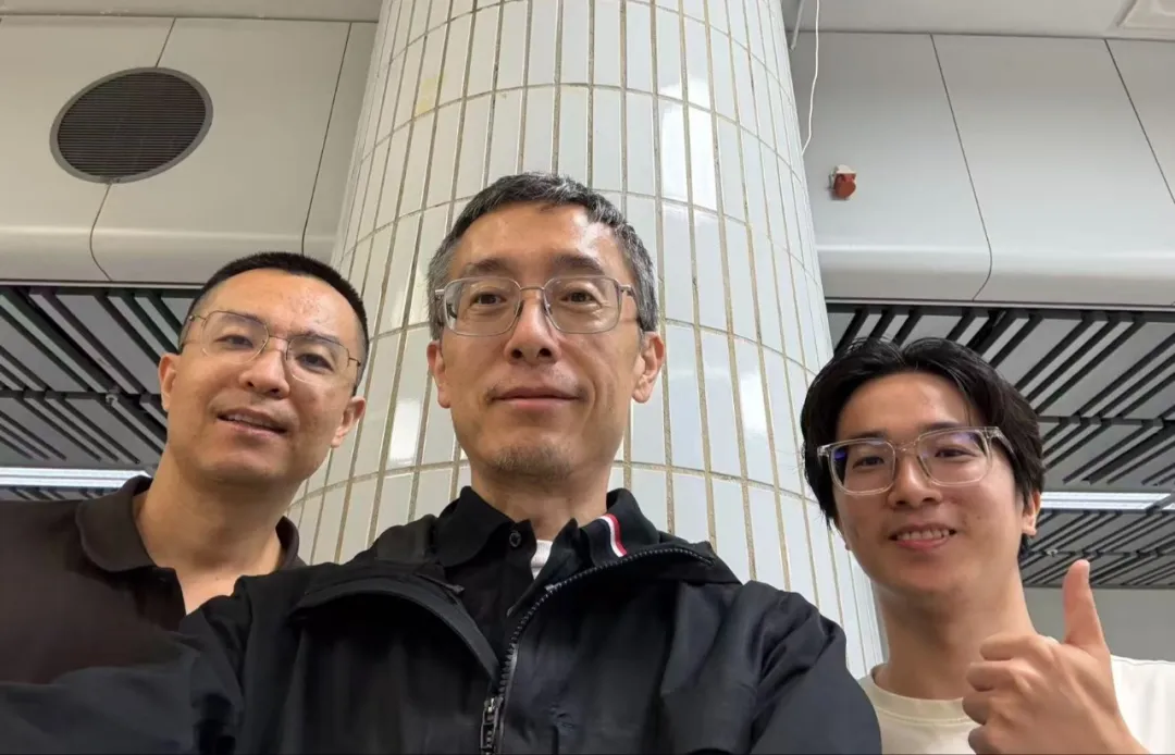
From left to right: Monkey, Steve Liu, Kim Jong-il
In the late '90s, he faced a post-00s team known as the "Little Genius with the Old Man".
The young team is dynamic and executive, and he is more involved in controlling and advising the direction of research. Technical problems are not due to qualifications that predict who says "who listens to who".
More interesting to him is the fact that the industry is close to the real issue.
In the early days of the world of photography, customers were brought in with real-life scenes. Academic research often dealt with problems that were carefully cut out, and companies were faced with data noise, efficiency and engineering constraints, more "dirty", more hands-on.
"You've got to do it, you've got to get feedback after you do it, you've got to adjust and you've got to do it again".
The team's division also corresponds to different parts of the mapping path: the spatial perception and collection team transforms the real environment into data, while the team's data intelligence studies help the team determine whether these data are useful to the model.
It's not the more the better, it's the question of who it's for.
He has long studied the relationship between data and models.
In different types of machine learning tasks, data is not as good as it gets. Different samples have different roles for the model, and the key is whether they help the model complete the target task.
He brought this idea to space data.
Real-world scenery gathering generates continuous video, depth information and other sensor data. There are repetitions and noise, and key but rare state changes. Data that is valuable for one task may not be useful for another.
"The value of the data may be determined by the added value of the task", said Mahan.
This means that spatial data governance cannot stop at weighing, cleaning, and marking. More importantly, it establishes a task correlation: what scenarios and states are covered by the data?
However, this does not mean that there is already a general "good data" indicator.
The team has discussed whether it is possible to establish a more general way of judging with information chains or information theory. The problem is that data values are highly related to tasks, models and evaluation conditions, and general measurements are still difficult. A common method at this stage is to put data into models or proxy models to observe its impact on target tasks.
So data selection is more like a closed loop job: first define tasks, then select data and rating indicators, and finally modify data strategies based on model performance.
For the mapping world, the answer is not just "how much", but "what data supports spatial intelligence, what data exposes the model's capabilities".
The model is "seeing", so why don't you understand space?
The basic model has seen a large number of images and videos, but that doesn't mean it automatically has a stable comprehensive spatial intelligence.
A two-dimensional image is a projection of a three-dimensional environment. A video camera records changes in appearance over time, but does not necessarily directly provide an object's identity, geographic location, shadowing relationship, or state change.
A packet is taken off the shelf, covered up on the way, and then reappears elsewhere. The model needs to be observed before and after the connection, to judge whether the same object changes, to record the location and state. If the evidence is insufficient, it should also retain uncertainty, rather than giving an unfounded definitive answer.
This type of problem requires systems to go beyond single-stroke testing.
The single-stroke test responds to "what was seen at this moment"; the dynamic state indicates that it will also respond to "where it was before, what happened, whether it can now be confirmed".
Cross-perspective, cross-time identity correlation and state maintenance are key to moving models from visual recognition to continuous spatial understanding.
Along this line, the mapping world breaks down spatial information into geometry, objects, relationships, memory, and uncertainty, and plans a processing chain from polymorphic acquisition, time-space alignment, spatial structuring, to dynamic tracking and predictive verification.
At the acquisition end, their devices combine information such as depth and infrared to provide insight beyond visual insight into the scene.
Technical keys also include a unified timeline and coordinate system, a cross-section to maintain object identity, record trajectory and state changes, and preserve original evidence and data sources.
After these processes, data can be converted from a video to samples that can be retrieved, selected and verified by object, time, location and task.
Real-time dynamic semantic space information
You can't judge a spatial model by just giving it a total score.
The data is organized and there is a way to test whether the model understands space or not. The team has recently been doing a benchmark study of space intelligence, hoping to form a set of Benchmarks to assess the ability of different models to understand space intelligence.
The input for spatial evaluation may be single image, multi-point photo, full video, real-time video streams, 3D sensor data, or interactive environments.
Tasks may include measuring positions, interacting objects, predicting future states, actively obtaining evidence, or even completing operations.
It's easy to confuse different capabilities with just an input model or a total score.
Asking a model a complete video and making the video gradually arrive, requiring it to observe and update memory, is not the same thing. The former can rely on retrospective, while the latter must test state maintenance, response times and information budgets.
Assessment extends from passive reasoning to active observation and interactive decision-making if models allow mobile cameras to gain new perspectives.
Therefore, the model answer to a spatial question cannot alone prove that it understands real space.
For a more explanatory assessment, several things need to be clarified: what information did the model see, can it look back on history, does it allow interaction, does the standard answer come from a real sensor or from a simulated state, and does the final score match geometric accuracy, identity continuity, predictability, or mission success?
The real scenario is not natural, nor is it the same as a reliable real value.
Sensor-setting errors, 3D reconstruction biases, and artificial marking all affect the reference response. The simulation environment is easy to control and reproduce, but the benefits of simulation do not necessarily migrate to reality.
Assessment, therefore, requires evidence from sources and testing models through unseen scenarios, future observations or controlled interactions, rather than relying on a single accuracy rate or model self-assessment.
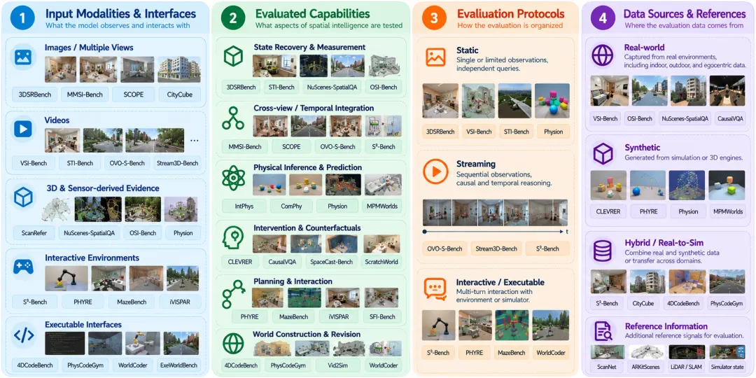
Space intelligence benchmarking system
Rating isn't about ranking, it's about telling the coach what to do next.
In Horse's view, evaluation is not just about ranking the model, but also about what data should be added to the next round of training. If the model often loses its object identity after being overshadowed, the next round will need to focus on overshadowing, cross-sectional associations and state restoration, data construction and tasks.
The world of mapping is exploring: using real-world scenario data to evaluate the base model, and then feedback on the model's failure patterns in data collection and training.
A post-training environment provides a carrier for converting the failure pattern into training tasks and learning signals. It revolves around a gap in the model's ability to expose repeatable tasks, organizes model-available observations and interaction interfaces, and verification mechanisms based on spatial evidence. The model completes the task through observation, response, or tool call, the environment is based on the evidence and the test results of the task rules, returns feedback or rewards, and the trainer uses the interactive trajectory and feedback to update the model.
Instead of just delivering static data sets, this form has the opportunity to actually access the post-training process of the model.
But to make feedback credible, there is a premise: the system needs to ensure that the reference state for verification is not disclosed to the model, and that the rewards are based on real time and space evidence, rather than merely judging whether the answer sounds reasonable.
He proposed comparing different supervisory methods under the same model, under the same budget conditions, and focusing further on unprecedented scenario performance, mission success rates, failure recovery and access costs.
The ultimate answer to this assessment is whether spatial supervision makes the model more reliable.
In "Robotics"What is it?Before the GPT moment".
Mapping technology is moving forward along a clear pipeline: data production engineering, post-training environment and verification research, and customer model access.
The value of this route will ultimately be demonstrated by the actual results: can spatial data access existing training pipelines? can evaluation locate model shortcuts? can training feedback lead to improved cross-scenario reproducibility?
In the future, there will be a "GPT moment in robotics".
But before that, spatial intelligence has to go through more detailed task definitions and real-world verification: from object identification to ongoing tracking, from passive response to active observation, from model scores to verifiable task results.
At the end of the interview, Mahan mentioned one of his favorite phrases:
Ever tried. Ever failed. No matter. Try again. Fail again. Fail better. ——Samuel Beckett
It doesn't matter if you try or fail; try again, fail again, but fail better.
This model is the process of enhancing intelligence in training, and the path forward for research and entrepreneurship: entering the real environment, understanding problems from observation, exploring possibilities with action, improving cognition based on reward, leaving a signal to learn from each failure, giving each training an opportunity to break original boundaries.
© THE